Welland County,
Ontario
See also (on this website):
Site Map for This Genealogy
Family
Tree of the Schneider Family of Welland County
Microfilm Records for Welland County
Names Identified on the Welland
County Microfilm Records
Families Identified
on the Welland County Microfilm Records
Names from the Ontario Archives
Welland County is the home of my Schneider
ancestors.
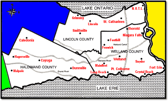
Location and Townships
Welland County is a peninsula in Ontario, Canada. It is bounded on the north
and west by Lincoln County (with Lake Ontario to the north of Lincoln County),
on the east by the Niagara River (and Niagara Falls), and on the south by Lake
Erie. Haldimand County is to the west. Across the river to the east are Niagara
County and Erie County in New York State.
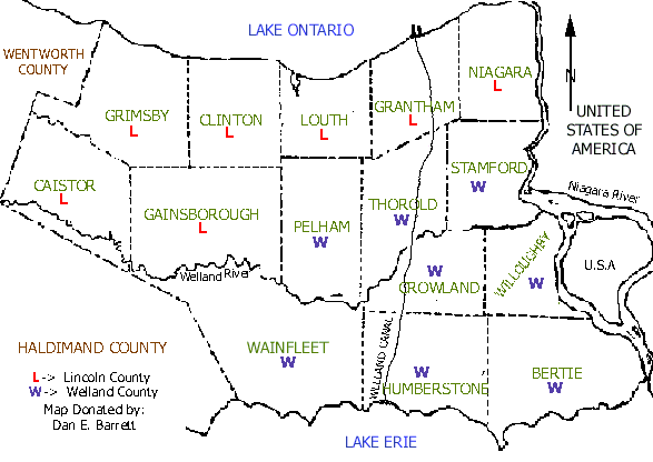
This map is from "Niagara Genealogy Locator -- By Map" at http://www.rootsweb.com/~onniagar/townshipmap.htm,
where it was contributed by Dan E. Barrett.
Welland County is divided into eight townships, each of which contains various
towns and villages. According to "Niagara Genealogy Township Index"
at http://www.rootsweb.com/~onniagar/welland/townshipindex.htm,
the townships are as follows:
- Bertie Township -- Bertie Bay, Buffalo Heights, Crystal Beach, Fort
Erie, Oakhill Forest, Ridgemount, Snyder, Stevensville, Thunder Bay
- Crowland Township -- Cooks Mills, Dain City, Welland
- Humberstone Township -- Bethel, Brookfield, Gasline, Humberstone,
Port Colborne, Sherkstone, Sugar Loaf Hill
- Pelham Township -- Effingham, Fenwick, Fonthill, Pelham, Pelham Centre,
Pelham Corners, North Pelham
- Stamford Township -- Clifton, Drummondville, Niagara Falls, Stamford,
Stamford Station
- Thorold Township -- Allanburg, Allanburg Junction, Black Horse Corners,
Centreville, Port Robinson, St. Johns West, Thorold, Turners Corners
- Wainfleet Township -- Beckett Bridge, Long Beach, Marshville, Marshville
Station, Ostyhon Corners, Perry Station, Sugar Loaf Hill, Wainfleet, Wainfleet
Station, Willow Bay, Winger
- Willoughby Township -- Chippewa, Douglastown, Netherby, White Pigeon
Historical Maps
Excellent historical maps of Welland County and other Ontario counties are
available on-line at "The Canadian Atlas Digital Project," http://digital.library.mcgill.ca/CountyAtlas.
These maps were drawn between 1874 and 1881. The maps show the names of lot
holders, and the website has indexes by name.
The maps for all of the Welland County townships were drawn in 1876. You can
determine this by using the website features to locate an individual person,
and call up the detail about that person.
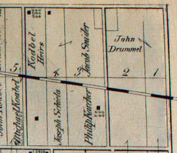
The image above is from the northeast corner of the Humberstone Township map.
It shows the lot owned by my ancestor Jacob
Snider (Schneider).
Roman Catholic Churches
The Catholic Diocese of St. Catherine's spans the counties of Welland, Lincoln,
and Haldimand.
This map is from "The Diocese of St. Catharines Parishes" at http://www.romancatholic.niagara.on.ca/parish.htm.
It shows each parish in the diocese.
Catholic parishes in Welland County, in the order of their founding:
- Niagara Falls: Our Lady of Peace (established 1837) 7021 Stanley
Avenue, L2G 7B7
- Snyder: St. Joseph (established 1849) R.R. # 2 (Netherby Road) Stevensville,
L0S 1S0
- Thorold: Holy Rosary (established 1852) 21 Queen Street South, Thorold,
L2V 3M7
- Port Colborne: St. Patrick (established 1859) 123 King Street, L3K
4G3
- Fort Erie: St. Michael (established 1860) 310 Central Avenue, L2A
3T3
- Niagara Falls: St. Patrick (established 1858) 4673 Victoria Avenue,
L2E 4B8
- Welland: St. Mary (established 1910) 90 Griffith Street, L3B 4G4
- Welland: Sts. Peter & Paul (established 1913) 300 Chaffey Street,
L3B 2Y8
- Niagara Falls: St. Ann (established 1913) 5740 Buchanan Avenue, L2G
3V3
- Welland: Paroisse du Sacre Coeur (established 1920) (French) 72,
rue Empire, L3B 2L4
- Niagara Falls: Sacred Heart (established 1924) 3882 Main Street,
Chippawa, L2G 6B6
- Welland: Our Lady of Hungary (established 1928) 337 Hellems Avenue,
L3B 3C2
- Port Colborne: St. Therese of Lisieux (established 1937) 379 Fares
Street, L3K 1W9
- Wainfleet: St. Elizabeth (established 1938) 19 M 41 Highway # 3,
L0S 1V0
- Fenwick: St. Ann (established 1940) 834 Canboro Road, L0S 1C0
- Port Colborne: St. John Bosco (established 1946) 375 Main Street
West, L3K 3V9
- Crystal Beach: St. George (established 1947) 56 Ridgeway Road, L0S1B0
- Port Colborne: Paroisse S. Jean-de-Brebeuf (established 1951) (French)
300, est rue Killaly, L3K 1N9
- Thorold: St. Aloysius (established 1951) 317 Morton Street, Thorold,
L2V 1C4
- Niagara Falls: Our Lady of the Scapular (established 1951) 6557 Thorold
Stone Road, L2J 1B2
- Welland: St. Augustine (established 1951) 295 St. Augustine Avenue,
L3C 2L2
- Welland: St. Kevin (established 1951) 303 Niagara Street, L3C 1K5
- Niagara Falls: Paroisse S. Antoine-de-Padoue (established 1955) (French)
4570 Chemin Portage, L2E 6A8
- Niagara Falls: St. Thomas More (established 1956) 6548 Dorchester
Road, L2G 5T5
- Welland: St. Andrew the Apostle (established 1957) 22 Golden Boulevard
E., L3B 1H4
- Fonthill: St. Alexander (established 1967) 50 Pelham Town Square,
L0S 1E0
- Welland: St. Anthony (Croatian) (established 1982) 360 River Road,
L3B 2S4
- Long Beach: St. Teresa of Avila (Mission Church of St. Elizabeth
Wainfleet) Lakeshore Road
Welland County Records on Microfilm
Comments? Suggestions? Send a
letter to Brian...